The Corfu Trail - Route
Since the Corfu Trail was established in 2001, thousands of walkers have followed it the length of the island. 180 kilometres long, Corfu's long-distance walking route leads into a landscape untouched by the mass tourism that has scarred parts of the coastline, delving through the central countryside which visitors rarely discover and explore. Such is the variety of Corfu's scenery that walkers spend no more than an hour in any one landscape; indeed, around every corner a new scene stuns the eye. From the vast beaches and juniper dunes in the island's south, through the rolling olive groves of the central section, to the karst plateau and rugged gorges in the north, the Corfu Trail reveals an island paradise ideal for walkers.
Walking the Corfu Trail
The Corfu Trail is waymarked in strategic locations with yellow signs, bearing the letters CT and a directional arrow. Between signs, yellow paint markers confirm the route. Since the most dramatic scenery and the biggest concentration of highlights are in the north of the island, the Corfu Trail takes walkers in a south to north direction.
The companion guide book, ‘The Official Guide to the Corfu Trail’, written by the Trail's creator, is available here as a hybrid audio and visual app, and as pdf file. The document you are reading now is not a route guide: It is a planner enabling you to decide where your overnight stops will be, and advising you on bus routes. Distances and times are approximate and do not include any lengthy halts. All buses set out from and return to Corfu Town.
Planning the Hike
Please first read the brief description of the route. In this planner, it is divided into ten days of walking, based on my original ‘Companion Guide to the Corfu Trail’, with some adjustments. Walkers booked with with tour operators on organised tours may follow a slightly different programme. If you plan to hike the Trail as an independent walker, the overnight locations you choose to overnight are your choice, according to how long you intend to walk each day and/or where you are able to find accommodation. Using the guide to times between possible overnight stops, below, you may plan each day to be a shorter or a longer hike than the main route plan. For a list of accommodation, please email info@thecorfutrail.com, citing your request. Please note that details may have changed since I compiled the list, and also that I have not personally tested any of the establishments.
If you plan to camp, please be aware that only one organised camp site exists on the course of the Trail, at Paleokastritsa. Be aware also that under Greek law wild camping is illegal, but as long as you respect property, cause no damage, and are discreet, you should not encounter any problems. Do not light a fire under any circumstances.
Kavos - Lefkimmi (Potami)
- Starting from just south of Kavos, The Corfu Trail leads quickly into olive groves and forest, then passes the ruined Monastery of Arkoudillas and descends to the seashore. Ascending the cliffs, it leads through neat fields to Spartera, then along shady olive grove tracks and through open country to Lefkimmi.
- Distance: 16 kms
- Time: 5 hours
- Ascent: 250 metres
- Accommodation: Kavos
- Limited accommodation: Lefkimmi, Spartera
- Bus: Kavos, Lefkimmi
- Facilities: Kavos (Shops, Tavernas), Lefkimmi (Shops, Tavernas)
Lefkimmi (Potami) - Agios Georgios (south end)
- Winding through the back streets, the route heads cross-country to reach the lush valley of Gardeno. The way now climbs onto a ridge, gradually heading for the dramatic west coast cliffs, and down to lovely Golden Beach. The resort of Agios Georgios is reached further along the shore.
- Distance: 17 kms
- Time: 5 hours
- Ascent: 150 metres
- Accommodation: Kavos
- Limited accommodation: Santa Barbara, Agios Georgios South
- Bus: Agios Georgios South
- Facilities: Santa Barbara (Tavernas) Agios Georgios South (Shops, Tavernas)
Agios Georgios (south end) - Paramonas
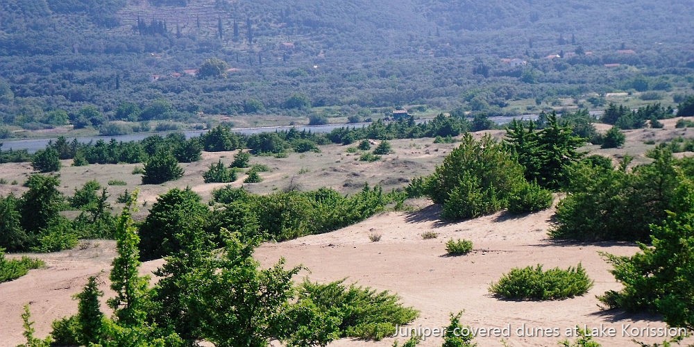
- The way continues along the shoreline and across sand dunes covered with a forest of juniper trees to Lake Korission. North of the lake, the Trail follows tracks and a section of road to reach Paramonas.
- Distance: 16 kms
- Time: 4 1/2 hours
- Ascent: 100 metres
- Limited accommodation: Halikounas, Paramonas
- Bus: Agios Mattheos (off route)
- Facilities: Korission/Halikounas (Tavernas), Paramonas (Tavernas)
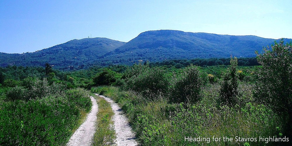
Paramonas - Stavros (Dafnata)
- With a sharp climb over the coastal ridge, the route turns inland to pass through the villages of Ano and Kato Pavliana and Vouniatades, then crosses the Messongi River Valley through olive groves and across heathland. Through Strongili, the Trail heads uphill again, to Komianata and Stavros.
- Distance: 15 kms
- Time: 5 hours
- Ascent: 600 metres
- Accommodation: Benitses (off route)
- Limited accommodation: Stavros
- Bus: Benitses (off route)
- Facilities: Strongili (Shop), Stavros (Bar/Taverna)
Stavros (Dafnata) - Pelekas
- From Stavros, a delightful footpath skirts Agii Deka Mountain to Ano Garouna, from where a very sharp ascent leads to the summit of Agii Deka, Corfu's second highest peak. The way continues down a cobbled mule path to Agii Deka village then along minor roads and tracks to Sinarades, after which undulating tracks above the west coast lead to Pelekas.
- Distance: 20 kms
- Time: 6 hours
- Ascent: 500 metres
- Accommodation: Pelekas
- Limited accommodation: Ano Garouna, Agii Deka, Sinarades
- Bus: Ano Garouna, Agii Deka, Sinarades, Pelekas
- Facilities: Agii Deka (Bar/Taverna), Sinarades, (Shops, Tavernas), Pelekas (Shops, Tavernas)
Pelekas - Paleokastritsa
- After visiting Myrtiotissa Beach (optional), a steep climb leads to Vatos, whereafter the terrain levels out in a pastoral valley. Through Giannades, the Trail ascends into olive-blanketed hills, heading for Liapades. Then it takes a very difficult footpath across a headland to Paleokastritsa.
- Distance: 24 kms (full route)
- Time: 6 1/2 hours (5 hours short-cut route)
- Ascent: 450 metres (200 metres with short cut)
- Accommodation: Paleokastritsa
- Limited accommodation: Liapades
- Bus: Liapades, Paleokastritsa
- Facilities: Vatos (Shops), Giannades (Shops, Tavernas), Liapades (Shops, Tavernas), Paleokastritsa (Shops, Tavernas)
Paleokastritsa - Agros
- The Trail heads from Paleokastritsa up a network of lovely cobbled footpaths to Lakones, then takes old donkey paths to reach Makrades. Through this lovely village (with an option to visit the medieval fortress of Angelokastro), it descends one of Greece's most remarkable footpaths, which zig zags down a sheer cliff. The way continues down an olive grove track and along the shoreline to the resort of Agios Georgios. A sharp climb from Agios Georgios to the village of Prinilas continues the walk. Then you descend to the picturesque village of Pagi. Tracks and a quiet road take you through agricultural land alongside the Megapotamos River and over the ridge through Aspiotades to Agros.
- Distance: 20 kms
- Time: 5 1/2 hours (plus 1+ hour to/from Angelokastro)
- Ascent: 400 metres (plus 300 metres extra to/from Angelokastro)
- Accommodation: Agios Georgios NW, Arillas & Agios Stefanos (off route from Agros)
- Bus: Agios Georgios NW, Agros
- Facilities: Lakones (Shops, Taverna), Makrades (Shops, Tavernas), Agios Georgios (Shops, Tavernas), Agros (Shops, Bars)
Agros - Sokraki
- The Trail leads through the two sprawling villages of Agros and Agios Athanasios, whereafter a quiet country road runs past a wealthy monastery, and tracks take you on to the road junction at Rekini. Leaving Rekini, the Trail heads for Valanio, a village deep in the middle of nowhere. Tracks then funnel the way up a deep valley. Along a cobbled path, you enter Sokraki, where the village square with its happy atmosphere calls for a stop.
- Distance: 12 kms
- Time: 4 hours
- Ascent: 250 metres
- Accommodation: Roda (off route from Rekini)
- Limited accommodation: Sokraki
- Bus: Rekini, Sokraki (limited)
- Facilities: Sokraki (Taverna)
Sokraki - Old Perithia
- Leaving Sokraki, the Trail follows tracks and paths through forest and cultivated land to Spartillas. Onwards, you are soon on a steep mountain footpath climbing a gully to a viewpoint at Taxiarchis Chapel. The Trail then crosses the 'Karst Plateau', Corfu's wildest scenery. You descend on a mountain track to the high col of the main ridge, and then to Old Perithia - a semi-ruined Byzantine village located in a high valley.
- Distance: 15 kms
- Time: 5 1/2 hours
- Ascent: 500 metres
- Accommodation: Ipsos & Barbati (off route from Spartillas)
- Limited accommodation: Spartillas, Old Perithia
- Bus: Spartillas (limited)
- Facilities: Spartillas (Taverna, Shops, Bar), Old Perithia (Tavernas)
Old Perithia - Saint Spiridon
- Starting, the Trail descends a gorge through thick forest, then continues down on paths and tracks past little settlements to a northern coastal plain. You reach the sea and follow the beach to the wild, bare headland which is Corfu's northernmost point, where a rough seashore path takes you to the end of the Trail at Saint Spiridon Beach.
- Distance: 12 kms
- Time: 3 1/2 hours
- Ascent: Mainly descent
- Accommodation: Saint Spiridon
- Limited accommodation: Almiros
- Bus: Almiros Main Road, New Perithia
- Facilities: Almiros (Tavernas), Saint Spiridon (Tavernas)
NOTE: Due to the disruption of the North East Coastal Path by building works, we have deleted the original loop section from the High Col, south to the coast and back to the High Col. This will be presented as an independent hike.
Overnight Accommodation
Approximate times between possible en route overnight stops, so you can plan your own programme.
(* Indicates limited accommodation)
- Kavos - Spartera*: 3 hours
- Spartera* - Lefkimmi*: 2 1/2 hours
- Lefkimmi* - Santa Barbara: 4 hours
- Santa Barbara - Agios Georgios South: 1 hour
- Agios Georgios South - Halikounas*: 2 hours
- Halikounas* - Paramonas*: 2 1/2 hours
- Paramonas* - Stavros*: 5 hours
- Stavros* - Agii Deka*: 2 1/2 hours
- Agii Deka* - Sinarades*: 1 1/2 hours
- Sinarades* - Pelekas: 2 hours
- Pelekas - Vatos: 2 1/2 hours (short cut, minus 1 1/2 hours)
- Vatos - Liapades*: 3 1/2 hours
- Liapades* - Paleokastritsa: 30 minutes
- Paleokastritsa - Agios Georgios NW: 4 hours
- Agios Georgios NW - Agros (bus to Arillas & Agios Stefanos): 2 1/2 hours
- Agros - Rekini (bus to Roda for accommodation): 1 1/2 hours
- Rekini - Sokraki*: 2 hours
- Sokraki* - Spartillas (walk to Barbati or Ipsos for accommodation): 1 1/2 hours
- Spartillas - Old Perithia*: 3 1/2 hours
- Old Perithia* - Almiros/Saint Spiridon: 3 hours